
7:35AM – Bremerton
I woke on this morning and immediately had a feeling that what I was about to experience would forever change the way I looked at the world. The excitement that ran across my body as I put my camera gear on the passenger seat of the rental car was the type of excitement that leaves your whole body shaking in anticipation of what you are about to experience. Well, the shaking may have been a result of the low 30-degree brisk mornings of Washington State. I jumped into the drivers seat and plugged in the coordinates of my final destination. “Maple Pass Loop”. It sits in the Cascade Mountains of Washington State. I made sure to select the route that looked more scenic even though it took me out of my way about 4 hours or so. I have often found that the road less traveled, is the road worth travel. My starting destination was that of Harstine Island, an island that is slightly southwest of Seattle.
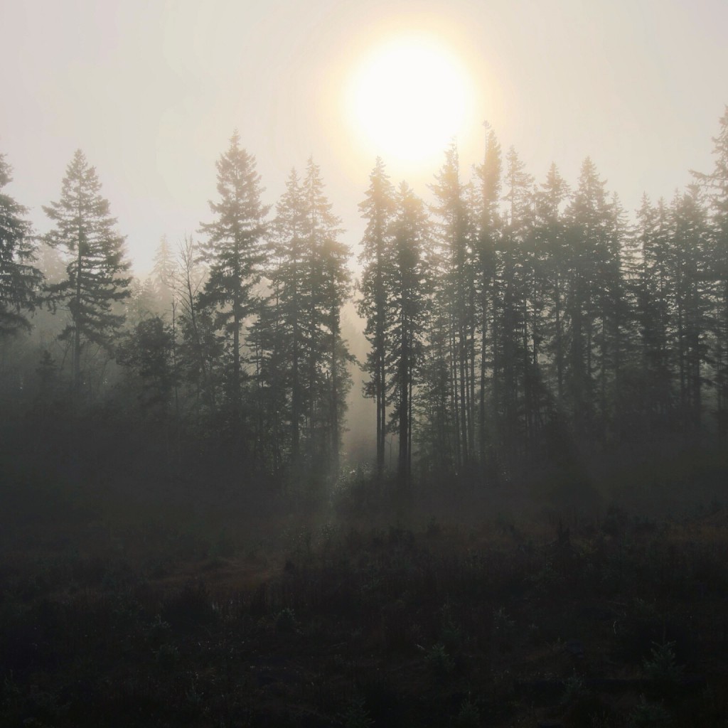
I started out going north oh Hwy 3 towards Bremerton. Not even 2 hours into the trip I was immediately amazed by the weather conditions of the day. A foggy start with the sun rising and breaking through at any chance it got. It was an eerie scene, but a scene that every photographer hopes for. I pulled over many times to try and capture the almost heaven like conditions of the morning, turning my 6 hour commute to my final destination into almost a 12 hour journey of its own. As you drive through the roads of Washington every turn is a new scene begging to be photographed and displayed, as if it was a still taken from an epic mountain adventure feature film. We have all seen these films, and we have all drooled over their beauty, but to be amongst it in real life, was something that left me a majority of the time with my mouth hanging wide open in astonishment on what sat in front of me.
9:50AM: Port Townsend Keystone Ferry
As I continued north to connect with Highway 104, the fog began to dissipate and blue skies become more of a commonality. I felt that I got somewhat lucky with the changing conditions, considering the amount of rainfall the area typically gets every year. The tall pines that lined the road left the sun breaking through lighting up the fog just right.
After some stops for photos and gas I continued north to arrive at Port Townsend. As I mentioned before, I was simply following the instructions of Google maps on my way to my final destination. I typically just let it take me where it wants, as it most likely takes me to the more interesting types of places and situation. This time was no different. As the map instructed me to “Turn Left in 30 feet” I looked at where it is telling me to go and stop for a moment in confusion. The mapping software was telling me to board a boat. Being from the south originally and living in Chicago for the last 4 years, I will have to be honest and say I have never boarded a ferry with a vehicle and was slightly nervous and unsure of what to do.
I decided to just go with it and try it out, as it was most definitely a new and exciting part of the adventure I was on. I continued on and followed the instructions of the mapping software and boarded the rental car and I on the “Port Townsend Keystone Ferry” This ferry is responsible for transporting passengers from one side of the “Strait of Juan de Fuca” to the other.
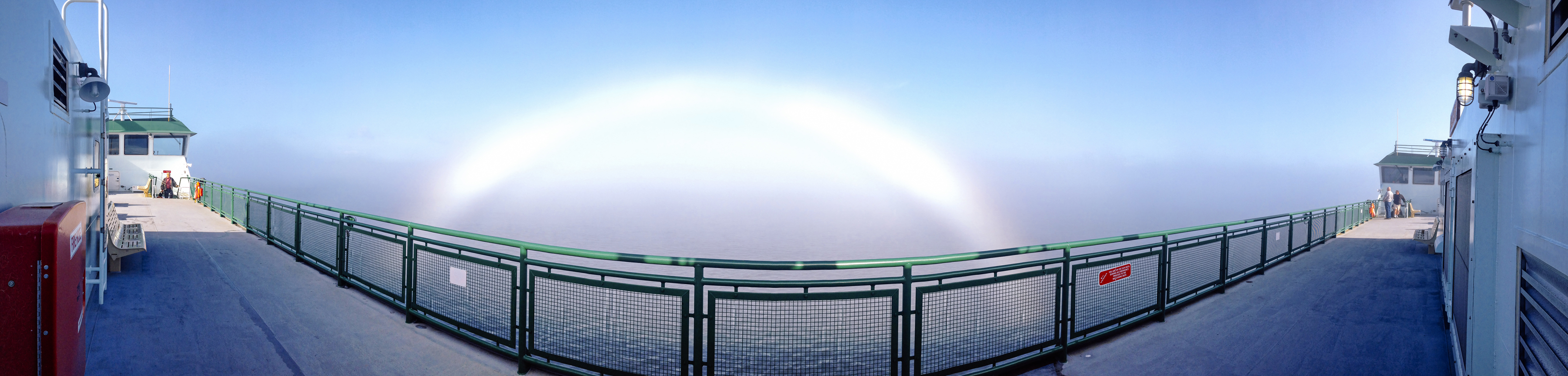
As the ferry departed Port Townsend we headed slightly east with a final destination of Coupeville, a cute little town nestled in the bay of the Salish Sea, and Puget Sound. The homes here are all out of another era, and were painted with vibrant primary colors of reds and yellows. As the ferry crossed the bay we were headed straight into a think wall of fog that was developing. I headed out to the upper deck with camera in hand to experience our transition from sunny skies to that of gray fogginess. As we entered the fog, I noticed a strange occurrence happening just to the side of the boat. The sun was shinny through the fog and creating a white rainbow. At first I was confused as to how this phenomenon was happening but shortly after first sight a woman walked up to me and explained on how the effect was created. I stood in amazement as the thick fog rolled across the railing and wood of the boat’s deck and the ships horn blaring to give warning of other ships that may not be able to see our boat traveling through.
11:15AM
Deception Pass
Deception Pass
11:15AM: Deception Pass
After arriving in Coupeville, I departed the ferry and continued north. I was headed toward Deception Pass. Before I left for this trip I did some research the day before and read up a little on the area. This helped create some excitement for my arrival, as I knew it would be a good place to do some sight seeing. I arrived at Deception pass to be greeted by a magnificent steel bridge. The Deception Pass Bridge was built in 1934 and connects the Strait of Juan de Fuca with the Saratoga Passage. It was named “Deception Pass” because it primarily was recorded as a small bay by the Spanish, but was later discovered to be a really a huge and turbulent channel.
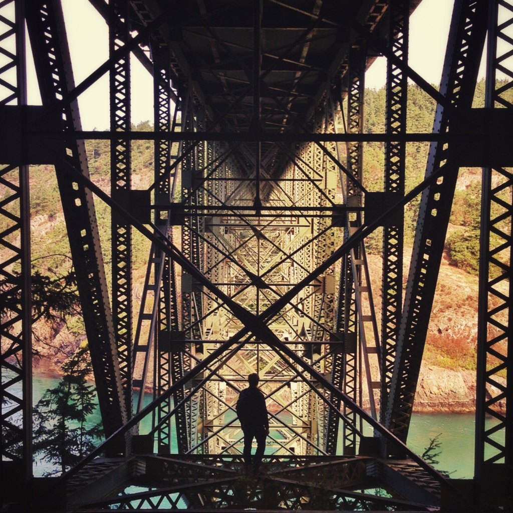
I proceeded to get out and get all my gear together to head over to take some shots of the bridge from underneath. When I arrive at the underbelly of the bridge I set up my gorilla pod stand with my iPhone set to a timer to take a photo every 30secs or so. I like to do this to document the process of getting a particular shot, and I felt this shot would be a good one for just that. After I had my phone all set up I headed deeper into the structure of the bridge, and climbed out on some of the steel beams to get a closer shot of the bridge. As I stood there taking my shots and focusing on the internals of the structure I noticed something moving around on the inside of the bridge. It appeared to be the silhouette of a man, climbing on the structure.
At first I honestly didn’t think much of it considering I was slightly out on the structure as well and thought many people must climb on this bridge since it was so accessible. I lifted my left arm and gave a little wave to the man out on the bridge, and as soon as it got my arm half way up in to the air the man started cursing and screaming at me. He was yelling out all type of profanity, which left me very confused. I thought, ok I guess he is not friendly and continued on with getting my shots. After I was done I noticed more and more people arriving around the lower part of the bridge but just continued on my way down to Cranberry Lake that was down the mountain below. After I returned back up the mountain to cross over the bridge I noticed a bunch more people were standing around as well as police officers and EMTs. It turns out that man that shouted all those profanities at me earlier, was threatening to commit suicide if a certain “Kristen” was not brought to the scene to talk with him. I stood around for a bit and snapped some shots of the desperate and upset man, and decided I would continue on with my trip as I didn’t think seeing a man fall to his death would leave a good vibe on the rest of my trip.
2:45PM
Diablo Lake
Diablo Lake
2:45PM: Diablo Lake
After the dramatic events at Deception Pass, I didn’t think it could get any more crazy or awesome. The next part of the route put me at the mouth of the Cascades. The Cascade Mountains are some of the most beautiful mountains I have seen. As I mentioned before I am from the southeast, so the type of mountains I am familiar with were more of a hill type of mountain then the jagged rocky formations of the Cascades.
As soon as you enter the start of the mountains you climb in elevation quite quickly. Putting the rental car to the test I continued onward towards Maple Pass. Around this time it started to rain a bit more the farther I got up the mountain. This left amazingly green a lush land, surrounded by deep tones of grey from the mountains that surround you. About 2 hours in, I arrived at Diablo Lake.
Diablo Lake is a reservoir, and located between Ross Lake and Gorge Lake on the Skagit River. Its waters have a vibrant green tint to it, created by fine powder that is grinded up by glaciers that surround it. The powder flows into the reservoir and stays suspended in the lake giving the lake its color. I took a bit of a break at the location to take in the views. The clouds at this point were almost whirling around the peaks of the mountains, as the rain would come and go. It was all a beautiful and surreal scenario.
Diablo Lake is a reservoir, and located between Ross Lake and Gorge Lake on the Skagit River. Its waters have a vibrant green tint to it, created by fine powder that is grinded up by glaciers that surround it. The powder flows into the reservoir and stays suspended in the lake giving the lake its color. I took a bit of a break at the location to take in the views.

5:20PM: Maple Pass Loop
As amazing as Diablo lake was to just stare out I knew I still had to get to my final destination of Maple Pass Loop, and was running out of day soon. So I jumped back into my rental and headed up the mountain some more towards the trailhead. After a bit more driving then I expected I arrived at Rainy Pass. It was around 5pm when I started on foot up the trail to towards my final destination of Maple Pass Loop.
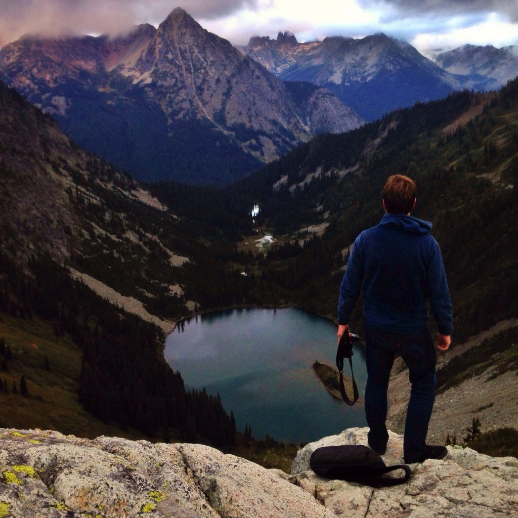
Maple Pass Loop is a loop trail that takes you up to a ridge that circles Lake Ann. Most people hike the trail in a clockwise direction, but since I was so limited in time I had read that if you wanted to get to the peak faster, you should go counter clockwise. It was a steeper climb but made for a faster trip to the top. I started on the trail and at this point was practically running up the mountain in excitement and worry that I was going to run out of daylight to get a sufficient shot of Lake Ann that sat below in the valley. The trail takes you through a wide range of scenery as you climb up the mountain. You start out in the thick muddy covering of the forest tress that sit at the base of the mountains, and are soon surrounded by flowers and scenic mountain views minutes later. As you climb higher Lake Ann starts to come into view, a distracting view, as you have to pay close attention to the rocky trail ahead.
I reached the top of the mountain just in time for sunset, but the cloud cover that was going on left for mystic type scenes to capture. I took as many shots as I could in the remaining amount of day that was left, and soon my battery in my camera went dead at the same time. I took a bit of time to just sit and gaze at its beauty a bit more before I started my decent back down the mountain. By this time it was dark and since I only knew one part of the trail for sure I decided it was best to head back down the mountain the same way I came up rather than trying to complete the loop in the unfamiliar second half of the trail.
6:20PM
Maple Pass Loop
I just stood for a bit, as I collected my thoughts on the day that I had just experienced. After a moment I headed back down to the rental car and changed out some socks and a shirt and began my drive back to Harstine Island. I took the expressway back to allow for the ride back to be one of reflection and less of adventure. I highly suggest a trip to the area, if you have never been as it left me with memories that I will forever have in my heart and soul. The trip also triggered some goals that I will attempt to tackle this coming April.
I just stood for a bit, as I collected my thoughts on the day that I had just experienced. After a moment I headed back down to the rental car and changed out some socks and a shirt and began my drive back to Harstine Island. I took the expressway back to allow for the ride back to be one of reflection and less of adventure. I highly suggest a trip to the area, if you have never been as it left me with memories that I will forever have in my heart and soul.
WOW! What beautiful pictures. I enjoyed reading about your trip and look forward to following your progress in April. Oh to be young again!
Thank you Ginny! I appreciate the kind words and the support and hope to get many awesome stories and photos from the hike! Cheers!
Oh Brandon, I just read this and I am so astonished to find your description of this area to match my own so perfectly! Sorry it took me so long to read it. Love you my nephew!
This is too cool!! I am too introvert to do something like this. I will continue to write my fiction. But i will remain vicarious through your experience. You are a brave soul. Stay safe and have fun!! Cannot wait to see the next entry.
I met your friend today and he told me about y’all’s trip u take beautiful pictures!have fun on your journey :))
I am in love with this website! I look forward to reading your blog when I get a minute and to seeing more pictures. Let me know when you guys make it to Ashland maybe we could all meet up.. I would love to hear more about your adventures.
Sincerely(girl who gave you a ride to Shasta)
Awesome article! I took a trip Through Portland, Seattle, and Vancouver. If you want some other ideas for what to do here, check out my article “Exploring the Northwest” on my website descending reality.com
http://www.descendingreality.com/exploring-the-northwest-vancouver-portland-and-seattle/
Also, my article on Olympic National Park will guide you through a neat day trip you can take on a sunny or rainy day!
Hi brandon,
I got some pictures of you overlooking Grinnell glacier that day.
how is Tonquin valley or Assiniboine peak?